Mobility analytics
Proposed capability, subject to development and validation.
PaulVision solutions
Long-term researchExplore how connected sensors and visual analytics can improve understanding of urban environments and infrastructure.
Proposed capability, subject to development and validation.
Proposed capability, subject to development and validation.
Proposed capability, subject to development and validation.
Proposed capability, subject to development and validation.
Proposed capability, subject to development and validation.
Proposed capability, subject to development and validation.
Local authorities · Infrastructure operators · Urban planners
Interactive technology laboratory
Explore simulated connected infrastructure, device availability and example notifications.
Concept simulation using synthetic information. No live equipment, aircraft, vehicle, customer or geographic data is connected.
All deployments require suitability assessments, testing, appropriate privacy safeguards and applicable regulatory approvals. No facial recognition is included in this product roadmap.
Technology overview
Smart Cities is a long-term research programme exploring how anonymous urban analytics and connected sensors could support infrastructure planning and operational understanding.
Use cases
Analyse pedestrian, cycling and vehicle movement.
Understand aggregate visitor activity.
Monitor selected environmental indicators.
Observe equipment conditions and authorised assets.
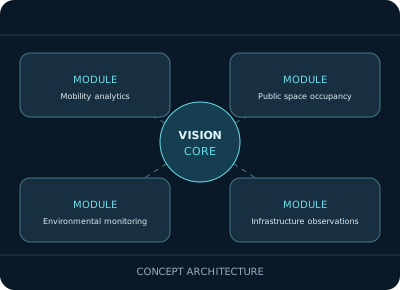
System architecture
Proposed architecture, subject to technical validation.
Public-sector governance, privacy impact assessments, procurement requirements, reliable connectivity and validated measurement methods.
Project collaboration
We welcome technical discussions, pilot project enquiries and potential research partnerships. Commercial availability remains subject to development and acceptance testing.