Aerial inspection data
Proposed capability, subject to development and validation.
PaulVision solutions
Future researchExplore aerial inspection, unmanned aircraft data integration and remote asset assessment.
Proposed capability, subject to development and validation.
Proposed capability, subject to development and validation.
Proposed capability, subject to development and validation.
Proposed capability, subject to development and validation.
Proposed capability, subject to development and validation.
Proposed capability, subject to development and validation.
Engineering · Agriculture · Infrastructure · Energy
Interactive technology laboratory
Explore simulated aerial survey coverage and sample observations.
Concept simulation using synthetic information. No live equipment, aircraft, vehicle, customer or geographic data is connected.
All deployments require suitability assessments, testing, appropriate privacy safeguards and applicable regulatory approvals. No facial recognition is included in this product roadmap.
Technology overview
AirVision is a future research programme for integrating authorised drone imagery, aerial inspections and geographical survey data into the PaulVision platform.
Use cases
Compare authorised aerial imagery across project milestones.
Explore visual and thermal inspection of solar energy installations.
Analyse crop conditions and authorised land imagery.
Support visual inspection of difficult-to-access infrastructure.
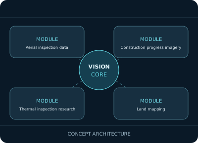
System architecture
Proposed architecture, subject to technical validation.
Appropriate aviation permissions, trained operators, suitable insurance, privacy assessment and approved operating procedures.
Project collaboration
We welcome technical discussions, pilot project enquiries and potential research partnerships. Commercial availability remains subject to development and acceptance testing.